![](/images/other/stat-length.png)
![Trail Walking La Verrière - Le Mesnil Saint Denis à Chevreuse - Photo](https://media.geolcdn.com/t/1900/400/ext.pjpeg?maxdim=2&url=https%3A%2F%2Fservices.sitytrail.com%2FGeolivesWS%2FDownloadMedia.ashx%3FTrailID%3D110099%26Media%3D5280_1.jpg)
Le Mesnil Saint Denis à Chevreuse
tracegps
User
![Length](/images/other/stat-length.png)
![Max alt](https://static1.geolcdn.com/siteimages/upload/files/1508320355ic_sort_altitude_max_24dp.png)
![Uphill gradient](https://static1.geolcdn.com/siteimages/upload/files/1508320355ic_sort_den_pos_24dp.png)
![Km-Effort](/images/other/stat-length.png)
![Min alt](https://static1.geolcdn.com/siteimages/upload/files/1508320355ic_sort_altitude_min_24dp.png)
![Downhill gradient](https://static1.geolcdn.com/siteimages/upload/files/1508320355ic_sort_den_neg_24dp.png)
![Boucle](https://static1.geolcdn.com/siteimages/upload/files/16400158638029165_repeat_loop_refresh_sync_direction_icon.png)
![Walking](https://static1.geolcdn.com/sitytour/trail-icons/101.png)
5h10
Difficulty : Difficult
![Scan this QR Code to open this trail in the SityTrail application](https://capi.geolives.com/qq0zvz2zws4bq2lad0pu/sitytour/trails/110099/qr.png?size=200)
FREE GPS app for hiking
About
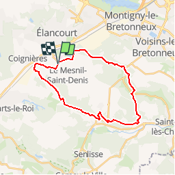
Trail Walking of 24 km to be discovered at Ile-de-France, Yvelines, La Verrière. This trail is proposed by tracegps.
Description
Circuit proposé par le Comité Départemental de Randonnée des Hauts de Seine. Parking départ : Coignères Etang du Val Favry. Gare départ Coignières Descriptif : GR11, Etang du Val Favry, Ferme de Bellepanne, le Pommeret, la Recette, la Maison du Garde, la Butte Ronde, la Motte, la Grande Maison, Chevreuse .... nb, la Guinguette … Chemin de Jean Racine : carrefour du Roi de Rome (16), le Moulin de Fauvreau.... PR16, la Lorioterie, Port-Royal, parcelles 20.21.26 … PR carrefour de la Minière, carrefour de Rhodon , étang des Noës, La Verrière coulée verte, le Mesnil-Saint-Denis stade, Coignières digue de la rigole, étang du Val Favry. Des sentiers ont pu être modifiés depuis la dernière validation et les itinéraires proposés n’engagent pas la responsabilité du Comité. Signalez-nous les modifications rencontrées pour mise à jour de la randothèque.
Positioning
Comments
Trails nearby
![Trail Walking Dampierre-en-Yvelines - _La Genèse - Photo](https://media.geolcdn.com/t/375/260/ext.jpg?maxdim=2&url=https%3A%2F%2Fservices.sitytrail.com%2FGeolivesWS%2FDownloadMedia.ashx%3FTrailID%3D746353%26Media%3D852eb799-755d-4473-ad2a-667c4a68a14c.jpg)
![Walking Walking](https://static1.geolcdn.com/sitytour/trail-icons/101.png)
Walking
![](/images/other/stat-length.png)
![](https://static1.geolcdn.com/siteimages/upload/files/16400158638029165_repeat_loop_refresh_sync_direction_icon.png)
![Trail Walking Dampierre-en-Yvelines - _Villages par mont et par vaux - Photo](https://media.geolcdn.com/t/375/260/ext.jpg?maxdim=2&url=https%3A%2F%2Fservices.sitytrail.com%2FGeolivesWS%2FDownloadMedia.ashx%3FTrailID%3D172084%26Media%3D1ba0ac7a-e5bc-4661-87da-e3aa68337b06.jpg)
![Walking Walking](https://static1.geolcdn.com/sitytour/trail-icons/101.png)
Walking
![](/images/other/stat-length.png)
![](https://static1.geolcdn.com/siteimages/upload/files/16400158638029165_repeat_loop_refresh_sync_direction_icon.png)
![Trail Walking Auffargis - _Les 1000 facettes d''Auffargis - Photo](https://media.geolcdn.com/t/375/260/ext.jpg?maxdim=2&url=https%3A%2F%2Fservices.sitytrail.com%2FGeolivesWS%2FDownloadMedia.ashx%3FTrailID%3D172079%26Media%3D17cc5ac4-6dc5-47bb-914f-f57b4e6dc7ba.jpg)
![Walking Walking](https://static1.geolcdn.com/sitytour/trail-icons/101.png)
Walking
![](/images/other/stat-length.png)
![](https://static1.geolcdn.com/siteimages/upload/files/16400158638029165_repeat_loop_refresh_sync_direction_icon.png)
![Trail Walking Saint-Forget - _Saint-Forget, fief de Cyrano de Bergerac - Photo](https://media.geolcdn.com/t/375/260/ext.jpg?maxdim=2&url=https%3A%2F%2Fservices.sitytrail.com%2FGeolivesWS%2FDownloadMedia.ashx%3FTrailID%3D172086%26Media%3D7b590dd2-7d00-4099-a55f-664d59f11356.jpg)
![Walking Walking](https://static1.geolcdn.com/sitytour/trail-icons/101.png)
Walking
![](/images/other/stat-length.png)
![](https://static1.geolcdn.com/siteimages/upload/files/16400158638029165_repeat_loop_refresh_sync_direction_icon.png)
![Trail Walking Lévis-Saint-Nom - _Le Vallon du Pommeret - Photo](https://media.geolcdn.com/t/375/260/ext.jpg?maxdim=2&url=https%3A%2F%2Fservices.sitytrail.com%2FGeolivesWS%2FDownloadMedia.ashx%3FTrailID%3D172087%26Media%3D296168f6-bac5-406d-9015-aae13e393b5e.jpg)
![Walking Walking](https://static1.geolcdn.com/sitytour/trail-icons/101.png)
Walking
![](/images/other/stat-length.png)
![](https://static1.geolcdn.com/siteimages/upload/files/16400158638029165_repeat_loop_refresh_sync_direction_icon.png)
![Trail Walking Le Mesnil-Saint-Denis - _Entre ancienne châtellenie et Ville nouvelle - Photo](https://media.geolcdn.com/t/375/260/ext.jpg?maxdim=2&url=https%3A%2F%2Fservices.sitytrail.com%2FGeolivesWS%2FDownloadMedia.ashx%3FTrailID%3D754427%26Media%3D98bcb1fa-3e08-461c-9cfd-0202e71bacca.png)
![Walking Walking](https://static1.geolcdn.com/sitytour/trail-icons/101.png)
Walking
![](/images/other/stat-length.png)
![](https://static1.geolcdn.com/siteimages/upload/files/16400158638029165_repeat_loop_refresh_sync_direction_icon.png)
![Trail Walking Lévis-Saint-Nom - _L'Yvette - Photo](https://media.geolcdn.com/t/375/260/ext.jpg?maxdim=2&url=https%3A%2F%2Fservices.sitytrail.com%2FGeolivesWS%2FDownloadMedia.ashx%3FTrailID%3D791900%26Media%3D1a0fab6c-bee3-420c-863c-ba0cc33379bb.JPG)
![Walking Walking](https://static1.geolcdn.com/sitytour/trail-icons/101.png)
Walking
![](/images/other/stat-length.png)
![](https://static1.geolcdn.com/siteimages/upload/files/16400158638029165_repeat_loop_refresh_sync_direction_icon.png)
![Trail Walking Saint-Lambert - _Sur les pas de Racine (deuxième partie) - Photo](https://media.geolcdn.com/t/375/260/ext.jpg?maxdim=2&url=https%3A%2F%2Fservices.sitytrail.com%2FGeolivesWS%2FDownloadMedia.ashx%3FTrailID%3D745749%26Media%3Db1edb432-b6c8-43f7-9f4b-66b807e05156.jpg)
![Walking Walking](https://static1.geolcdn.com/sitytour/trail-icons/101.png)
Walking
![](/images/other/stat-length.png)
![](https://static1.geolcdn.com/siteimages/upload/files/16400158638029165_repeat_loop_refresh_sync_direction_icon.png)
![Trail Walking Magny-les-Hameaux - Boucle 23 km à partir de Port Royal des Champs - Photo](https://media.geolcdn.com/t/375/260/9a76b572-9029-4a25-99b4-82cf64e08344.jpg&format=jpg&maxdim=2)
![Walking Walking](https://static1.geolcdn.com/sitytour/trail-icons/101.png)
Walking
![](/images/other/stat-length.png)
![](https://static1.geolcdn.com/siteimages/upload/files/16400158638029165_repeat_loop_refresh_sync_direction_icon.png)